Stage 1 - Wessex Ridgeway - Lyme Regis to Thorncombe - April 28th 2025
- John Tippetts

- May 25, 2025
- 5 min read
Updated: May 1
Official Stage Statistics
Route distance – 11.12 miles
Duration - 5 hours 4 mins
Total ascent – 2016 feet
Total descent - 1532 feet
Highest point – 845 feet

Logistics
Drive to Premier Inn Seaton EX12 2NA & stay overnight (Sunday)
Drive to Axminster & park car EX13 5NX RingGo 42923
Catch X51/X53 Jurassic Coaster bus to Lyme Regis - 08:13 then hourly - 27 minutes
Walk to Thorncombe
Taxi back to Axminster & pick up car – M Cabs 01297 442222
Drive to Premier Inn Seaton EX12 2NA & stay overnight
Thorncombe is not blessed with buses to get me back to my car; therefore, I would need to get a taxi. The reason I chose to park in Axminster for the day rather than Lyme Regis was down to the cost of taxis. It was much cheaper to get a taxi to Axminster than it would have been to get one back to Lyme Regis and I can be mean when it suits!
My Walk
I knew that between Lyme Regis and Thorncombe there would be no shops or pubs to buy water or food. Bearing in mind the weather forecast for the day which was warm and sunny I made sure I was loaded with 2 large bottles of water. At breakfast I’d helped myself to a couple of pains au chocolat and a banana to eat for lunch. My backpack was also loaded with my drone controller and spare batteries as I knew there would be some great aerial photo opportunities. Number one schoolboy error of the day was that I discovered that I’d left the actual drone at the hotel; so, I’d be carrying a load of pointless excess weight all day. I had at least remembered my camera so wouldn’t have to rely on my phone.


Anyway, just after 09:00 I set off from sunny Lyme Regis on the start of my 2025 walking challenge. Clutching the 13 pages of detailed walking instructions, spirits were high as I walked along the River Lim within the town. Worryingly I soon discovered that the instructions were brilliant just as long as you followed each step to the letter and never took your eyes off them! The way that they were written meant that you miss one step and you were b***ered! It would then be necessary to refer to the OS Maps app. This is where I immediately started to miss the signage that National Trails benefit from. Constantly relying on the instructions, looking out for Wessex Ridgeway waymarkers and referring to the OS Maps app would lead to so many wrong turnings being taken all week.


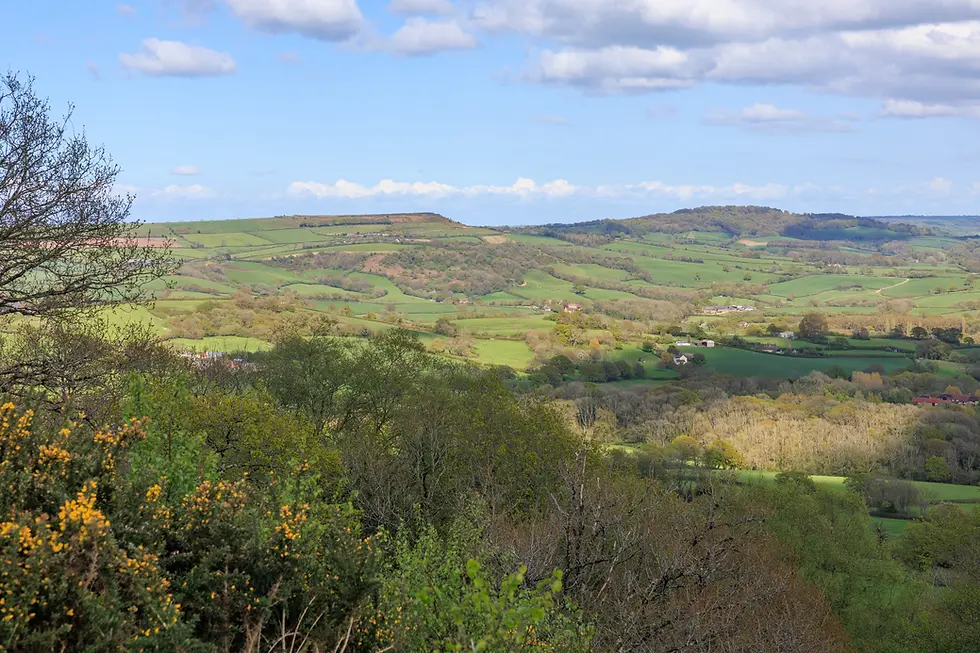
The path gave way to a wood known as Hole Common which was full of bluebells. I would very quickly become bluebell blasé. I deliberately chose to start my challenge at the end of April because I wanted bluebells and I certainly wasn’t disappointed. It was a little disconcerting to cross paths with a dog walker who was wearing wellies and the path through the woods was pretty muddy in places resulting in mud up over my ankles. I emerged triumphantly from Hole Common at the side of the busy A35 at Penn. My instructions told me to cross the road and admire the fabulous view. It’s fair to say that it really was a fabulous view of green fields, trees, hedges and hills for as far as the eye could see; the first ‘Wow!’ moment of the day.


A couple of miles further on and I took the first wrong turning of the day. As mentioned earlier I didn’t want to spend my whole time looking at the printed instructions or my phone. At a junction where I could turn either left or right, in the absence of a Wessex Ridgeway waymarker (or indeed any other trail's waymarker) I took a bad decision to turn right up a really steep hill. Lovely views from the top of the hill but then I had to come all the way down again. Back on track I reached the village of Wootton Fitzpaine, one of the lowest places on this stage.


Now I started the long climb up towards Coney’s Castle, site of a small Iron Age hill fort. There were fabulous 360 degree views all the way up to the fort which at 730 feet high is listed as the 19th highest hill in Dorset. The National Trust now looks after Coney’s Castle which at this time of year is carpeted with bluebells. The fort is bisected by a small lane that leads to Lambert’s Castle Hill. A bench by the roadside overlooking the countryside provided a perfect spot for me to take a break and eat my banana & pains au chocolat I’d taken from the Premier Inn.


Duly refreshed I continued along the lane with another steep climb up to Lambert’s Castle Hill. At 850 feet it’s listed as the 9th highest hill in Dorset. The hill is topped by an Iron Age hill fort, Lambert’s Castle that is around 2,500 years old. The hilltop was used as a racecourse at some stage and was also the site of a fair for over 200 years. Once again there were fabulous far-reaching views. I really wished I’d had my drone with me! This was definitely the high spot of the walk.
However, to rectify matters, I returned in April 2026 armed with my drone and so glad I did!


For the next couple of miles after Lambert’s Castle there was a relatively steep drop followed by a gentler climb through woods and trees before the path dropped once again into Thorncombe where I chose to end this stage.


Thorncombe is a really pretty village but it has a rubbish phone signal. I had to walk a hundred yards up the road to get a signal to phone for a taxi to pick me up and take me back to my car in Axminster. £23 was very reasonable I thought for a 9 mile journey. As he was driving back my driver arranged for another firm to bring me back the following morning.
So, stage 1 completed and the logistics had worked perfectly! As for my skills in following written walking instructions, there was certainly room for improvement. Hopefully I'd do better tomorrow.


Comments