Stage 18 - Icknield Way Path - Ivinghoe Beacon - Toddington - August 8th 2025
- John Tippetts

- Apr 21, 2025
- 10 min read
Updated: May 2
Official Stage Statistics
Route distance – 16.43 miles
Duration - 6 hours 28 mins
Total ascent – 1103 feet
Total descent – 1500 feet
Highest point – 765 feet

Logistics
Drive to Ivinghoe Beacon Car Park, Beacon Road HP4 1NF (OS SP963159)
Walk to Toddington
Get bus 42 or E back to Dunstable
Get taxi to Ivinghoe Beacon Car Park £25
OR
Get bus 61 61A or X61 to Ivinghoe Beacon stop on B489 and walk to car park
Pick up car
Drive to Portmill Lane Hitchin car park SG5 1DJ - free between 18:00 and 08:00
Walk across to Premier Inn and stay overnight
My Walk
This was my first stage of the Icknield Way. I used to live and work in Dunstable and was therefore familiar with much of the route. I even lived in Icknield Street, so ‘Icknield’ has always meant a lot to me! However, having moved away from the area more than 30 years ago I was keen to see what if anything had changed. I was really shocked to see the massive housing and industrial developments that have taken place to the north of Dunstable and Houghton Regis and the A5-M1 Dunstable Northern Bypass and junction 11A of the M1 that opened in 2017. Dunstable town centre has also changed significantly and not necessarily in a positive way I’m afraid to say. From my experience of having now walked this stage I’m assuming slight changes were made to the route of the Icknield Way in the light of the Dunstable Northern Bypass back in 2017.
The Icknield Way doesn’t actually start from the top of Ivinghoe Beacon as you might think it should; instead, there is a green Icknield Way sign about 600 yards before the top pointing you towards the start of the trail. The Icknield Way is the only trail of the 6 that comprise the Great Chalk Way that greets the walker at both the start and the finish with a fanfare. The fanfare in this case is a stone milestone at Ivinghoe Beacon and a similar one at Knettishall Heath – although at Knettishall Heath it’s well camouflaged! There is also one at Balsham which is where the official opening ceremony of the Icknield Way Path was carried out in 1992.


The start of the Icknield Way Path is also the start of the 7 mile section of the trail known as the Ridgeway Link. The link path follows the Icknield Way to Dagnall, Whipsnade and then across Dunstable Downs to the Chilterns Gateway Centre. This visitor centre, managed by the National Trust, provides the facilities lacking at Ivinghoe Beacon and has outstanding views for miles around. Beyond the visitor centre I’d descend the downs into Dunstable, walk around the outskirts of Houghton Regis and eventually cross the Dunstable Northern Bypass at Thorn. Beyond Thorn, the landscape would quickly become more rural again. The path would pass through the hamlet of Wingfield before passing Chalgrave Manor Golf Club.
Beyond the golf course I’d have 2 options for crossing the M1, both of which filled me with dread due to my irrational fear of high, narrow bridges – gephyrophobia! Option 1 would be to bear right and cross a narrow pedestrian footbridge over the motorway. This would eventually bring me out in Upper Sundon. Option 2 would be to bear left, walk into Toddington and then cross the motorway using the narrow bridge at Toddington Services reserved for emergency services vehicles and Travelodge guests. This option would bring me out close to Harlington. Option 1 is the official route, whilst Option 2 is the official alternative route. Having viewed the 2 bridges on Google Maps I’d already decided there was no way I’d be crossing either of these with 8 lanes of fast moving traffic underneath me! So, what did I do? Read on!
My day began with a 60 mile drive from home to the Ivinghoe Beacon car park off Beacon Road. This is where the Great Chalk Way information board is located.

It was a beautiful start to the day and as it was only 9 o’clock I treated myself to a climb to the top of the Ivinghoe Beacon to admire the 360° views including the Whipsnade chalk lion in the distance. I’d been to the top a couple of days ago but you can never tire of the views from up there.

Back down at the start of the Icknield Way, the path initially descended alongside a couple of large fields before entering some woodland that led into The Coombe, a wooded valley known for its muddy paths and steep steps. Fortunately, in August it was bone dry. It was certainly a steep climb and I was grateful for the steps. At the top the path opened up to give views of the Whipsnade chalk lion and the Downs.


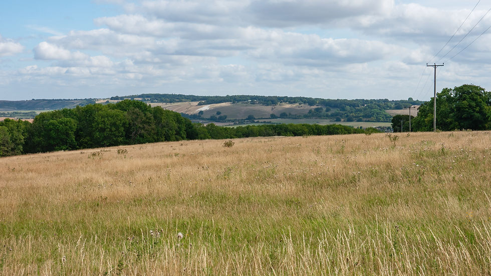
The path brought me down into the village of Dagnall and of course, a climb up towards Whipsnade then followed. This included crossing a few of Whipsnade Park Golf Club’s fairways.


Beyond the golf course the path continued climbing as it passed between the high fenced edges of Whipsnade Zoo to the left and high hedges to the right – so not a great deal to see and certainly not the huge white chalk lion that everyone associates with the zoo. The lion, which was carved between 1931 and 1933, is about 160 yards long nose to tail and is believed to be the largest chalk figure in England. In fact, it's so big it was covered during World War II as it would have been a very useful navigation aid to enemy planes. A band of volunteers is needed to keep it weed free.


Eventually I emerged into Whipsnade itself with its village hall, green and Tree Cathedral! I’d been to the Tree Cathedral before but couldn’t make out the outline of the Cathedral. Similarly, this time but maybe it’s because all the trees were in full leaf and I was too impatient to explore it fully. I therefore decided to return later in the year with my drone to help me get a better idea of the floor plan. I did this in December 2025 on an incredibly cold but very sunny morning.


Emerging from the ‘Cathedral’ I was soon walking along the Dunstable Downs, one of the highlights of this walk. At almost 800 feet, the Dunstable Downs are the highest point in Bedfordshire and this 2 mile section provides fabulous views of Buckinghamshire and Bedfordshire countryside, if not further. Halfway along, the Chilterns Gateway Centre, managed by the National Trust provides a café, toilets, shop, visitor information and car parking. As it was about lunchtime I stopped here for a coffee and a sandwich I’d brought with me.
As it was in the middle of school summer holidays and it was a gorgeous day, it was lovely to see so many families enjoying the downs with picnics and flying kites. There was no excuse to be stuck indoors playing computer games today.


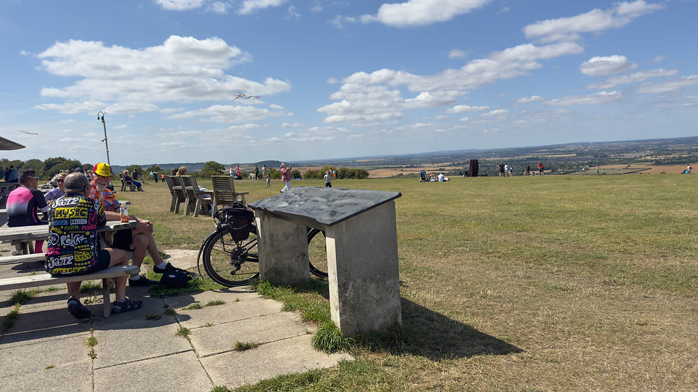

Kites (including the red variety) weren’t the only things in the air; down below was the London Gliding Club and to the right, away from most of the families, a number of brave souls attached to their paragliders, were launching themselves from the top of Pascombe Pit.


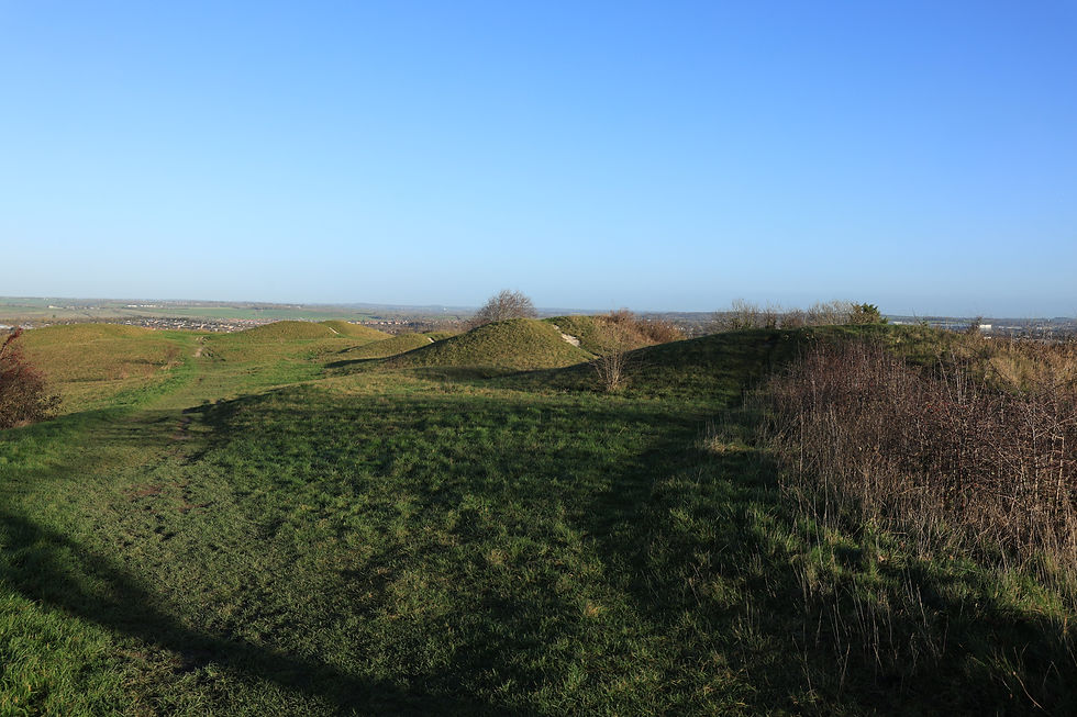
As I came to the end of the Downs, the path began to descend slowly into Dunstable. I passed what I thought at the time must be a BMX track – a number of grass mounds with an exposed chalk track running down the middle of each. It was only after I got home that I realised these mounds were anything but a BMX track! They were in fact the Five Knolls burial chambers – what an idiot!! The National Trust explains the history of these 4000 years old chambers, now recognised as a Scheduled Monument. It’s a shame though that people weren’t respecting them.
As I hadn’t thought anything of them at the time I didn’t bother taking any pictures, so I went back in December 2025 with my drone as part of an Icknield Way ‘mopping up’ exercise of things I wish I’d photographed. There are in fact seven chambers - three bell barrows, two bowl barrows and two pond barrows. As I'm not sufficiently well versed in types of barrow, I have no idea which is which in my photos!


Beyond the BMX track and having crossed the main road between Dunstable and Tring, the walk continued on a track at the side of the Beecroft housing estate. After walking along 4 virtually straight paths and tracks for almost 1½ miles I arrived at a bridge that carried the former Leighton Buzzard to Dunstable railway line that closed in 1967. Today with the tracks lifted, Sewell Cutting is not only used by walkers and cyclists along its firm and flat path but it is also a narrow wildlife haven. A big success story! Incidentally, Dunstable is in the top 20 largest towns in England without a railway station!
Having reached this bridge at Sewell Cutting I hadn’t realised that I’d walked past Maiden Bower, a Neolithic hillfort. Again, I hadn’t done my homework before setting off on this walk. In my defence, unlike other hillforts I’d encountered along the Great Chalk Way, Maiden Bower isn’t exactly by the side of the path and you’d have to know what you were looking for as you passed by the turn off leading to it.
Feeling guilty about missing the fort in August, I returned in December 2025 with my drone as another part of my mopping up exercise.
Having found it, from the ground you might not realise that what you were looking at was a hillfort. What remains of the rampart is covered in hawthorn bushes and trees and brambles. This is certainly a good thing since it deters people from vandalising it. One side of the rampart has collapsed into a former chalk quarry right by the side of the fort. The ditch has been filled in and is no longer visible and much of the interior has been under cultivation in recent times.
The site has been subject to vandalism over the years. One of the worst was about 20 years ago when vandals used a stolen mechanical digger to damage the rampart and cut a number of holes from the centre of the fort. The fort has also been used as a dumping ground for stolen cars after the drivers have had their fun driving round the fort and then torching them. Sure enough, there were two torched cars on the site when I visited in December 2025! There was also evidence of people riding off-road motorbikes around the fort.
I'm guessing this is what happens when towns expand so close to historical artifacts like this.

Continuing under the Sewell Cutting bridge I passed through the pretty hamlet of Sewell and then after walking along the side of a couple of fields I emerged onto a busy roundabout on what in my day was the A5 Thorn Turn but is now the A505. After crossing the A505, the path continued between a huge warehouse and a large Amazon Fulfilment Centre and then on through a development of new houses towards the Dunstable Northern Bypass. Wow! These buildings and houses certainly didn’t exist when I lived in Dunstable – everything is so new. An Icknield Way waymarker directed me onto a footbridge over the busy 4 lanes of traffic. The height and width of the bridge made it bearable for me to cross it without my stomach churning!


Safely on the other side of the bypass, the path initially continued parallel to the bypass but then took a left away from it and peace and tranquillity returned. I continued walking on the edge of a number of fields before entering the hamlet of Wingfield. More edge of field walking brought me to Chalgrave Manor Golf Club. Not sure I was meant to cross a couple of fairways but nobody told me off. Just beyond the golf course I hit Luton Road and this is where I was given the option to turn to the right to follow the ‘standard’ Icknield Way or bear left towards Toddington. The ‘standard’ way would take me onto the narrow footbridge over the M1; well, that was a non-starter for me. The alternative route would take me onto the emergency vehicles bridge over the motorway at the Toddington service area; the lesser of 2 evils for me.


I followed the Toddington route across a field and through some woodland and eventually emerged in the centre of Toddington. The village was much bigger and prettier than I remembered from when I worked for Barclays in Dunstable and we had a sub-branch in Toddington. Both the branch and sub-branch have now closed. Dunstable closed in October 2023 and is now a slot machine and online bingo paradise! I suspect Toddington sub-branch closed many years before.


I walked the extra mile to the motorway bridge…..took some photos…….and walked back into Toddington! I knew all along I wouldn’t be able to walk across it and had already decided that I would start the next stage of the Icknield Way tomorrow on the other side of the M1 at Harlington.


So, back in Toddington I caught a bus back to Dunstable and got a taxi to take me back to my car at Ivinghoe Beacon. From there I drove to the Premier Inn in Hitchin. I chose Hitchin because tomorrow’s stage would finish at Ickleford, just a short bus ride or walk from Hitchin town centre.
By the time I got to the Premier Inn it was gone 8 o'clock. I really couldn't be bothered getting showered and then go out to find somewhere for my tea, so I settled on eating in the hotel's restaurant. The poor girl who checked me in was also having to man the bar as well as cook and serve the food. I say 'cook' the food. I did ask her and she confirmed that what I ordered was simply microwaved! I didn't feel so bad after she told me that.
After leaving my house at 7:30 this morning, today had been a very long but thoroughly enjoyable day. Tomorrow should be an easier day and I hope it will be as good fun.


Comments