Stage 22 - Icknield Way Path - Great Chesterford to Stetchworth - August 17th 2025
- John Tippetts

- Apr 17, 2025
- 6 min read
Updated: Jun 2
Official Stage Statistics
Route distance – 17.22 miles
Duration - 6 hours 45 mins
Total ascent – 1102 feet
Total descent – 873 feet
Highest point – 381 feet

Logistics
Drive to Rustat Avenue Cambridge & park car - JustPark
Walk to Cambridge Station
Catch train to Great Chesterford Station
Walk to Stetchworth
Walk to Dullingham Station – 2 miles
Catch train to Cambridge Station - 2 Hourly at 21 mins past the hour on Sundays
Walk to Rustat Avenue Cambridge & pick up car
Drive home
My Walk
Continuing my walk across East Anglia towards the sea, the fifth stage of the Icknield Way Path would begin in Essex but soon cross into Cambridgeshire before finishing close to Newmarket, the ‘Home of Horseracing’.
Starting from Great Chesterford, a climb and descent into the village of Linton would be followed by another climb up Rivey Hill. This would be the extent of climbing, with the rest of the walk relatively flat. The walk would continue through the Cambridgeshire countryside, passing the villages of Balsham, Brinkley and Borough Green before reaching Stetchworth.
Getting to the start of today’s walk was the reverse of getting back from Great Chesterford 2 days earlier. I got up really early and drove towards Cambridge. Having deemed the Just Park app a big success, I found and booked myself another parking space in the same street close to Cambridge Station. I was there by 7:15 and caught the first train of the day to Great Chesterford, arriving shortly after 08:00. The station itself is about ½ mile from the village.

Needless to say, it was yet another cracking day with a cloudless sky. After walking through the village, I emerged onto a track which climbed steadily for about 2½ miles, reaching the highest point of today’s walk, more or less on the Essex/Cambridgeshire border. There were some lovely views of the surrounding countryside. The path then started going downhill, dropping towards the pretty village of Linton.


Linton is officially a village, albeit quite a large one; it even has a zoo – although it’s primarily a breeding centre for endangered species.


The Icknield Way brought me into a large, well-maintained recreation ground, before turning right and crossing an ornate bridge over the River Granta and into a residential area.

However, had I carried on for a couple of hundred yards I would have come to the Linton Clapper Stile, one of only 16 clapper stiles known to be surviving in the UK. Unlike all other stiles, a clapper stile has moving parts which make it much easier to climb over. The stile has planks that are pivoted on a central post and are weighted at one end. A walker pushes down on the unweighted ends and while holding the planks down, crosses through, When the walker lets go, the planks return to their horizontal starting position. The 'clap' is the noise made by the planks as they touch each other. Linton Clapper Stile
I only heard about Linton's clapper stile long after I'd completed my walk but having seen a photo of it I just had to go back to try it out for myself. So, in May 2026 I returned just to test out this wonderfully simple piece of engineering! I now know why people who appreciate the simplicity of the engineering get so excited - it's absolute poetry in motion and I'm so glad to have seen it and tested it out - not that my movements could be described as 'poetry in motion' before anybody says it! I now have to seek out and test some of the other remaining clapper stiles and at the same time improve my 'clapper stile crossing' technique.
Incidentally, for those people wanting to tell me off, I didn't leave the gate in the background open! A local resident was carrying out some tidying up of the overgrown vegetation on both sides of the fence at the time! In fact, the video was staged. I only went to Linton to see the clapper stile for myself and didn't walk beyond it.

Having walked through the village the path climbed up the relatively steep Rivey Hill alongside a most impressive field of plants with purple flowers. The Linton Village Community Life Facebook page assured me they were borage plants! I learned this about borage - ‘Borage is harvested for its seeds (for GLA-rich oil in supplements and cosmetics), its cucumber-flavoured leaves (eaten fresh, cooked, or used in teas), and its pretty blue flowers (used as garnishes in drinks and salads), with the whole plant also used as animal fodder and soil improver, while the flowers provide excellent nectar for bees.’. All in all, it seems that borage is a great plant! The things I learn on my walks!!


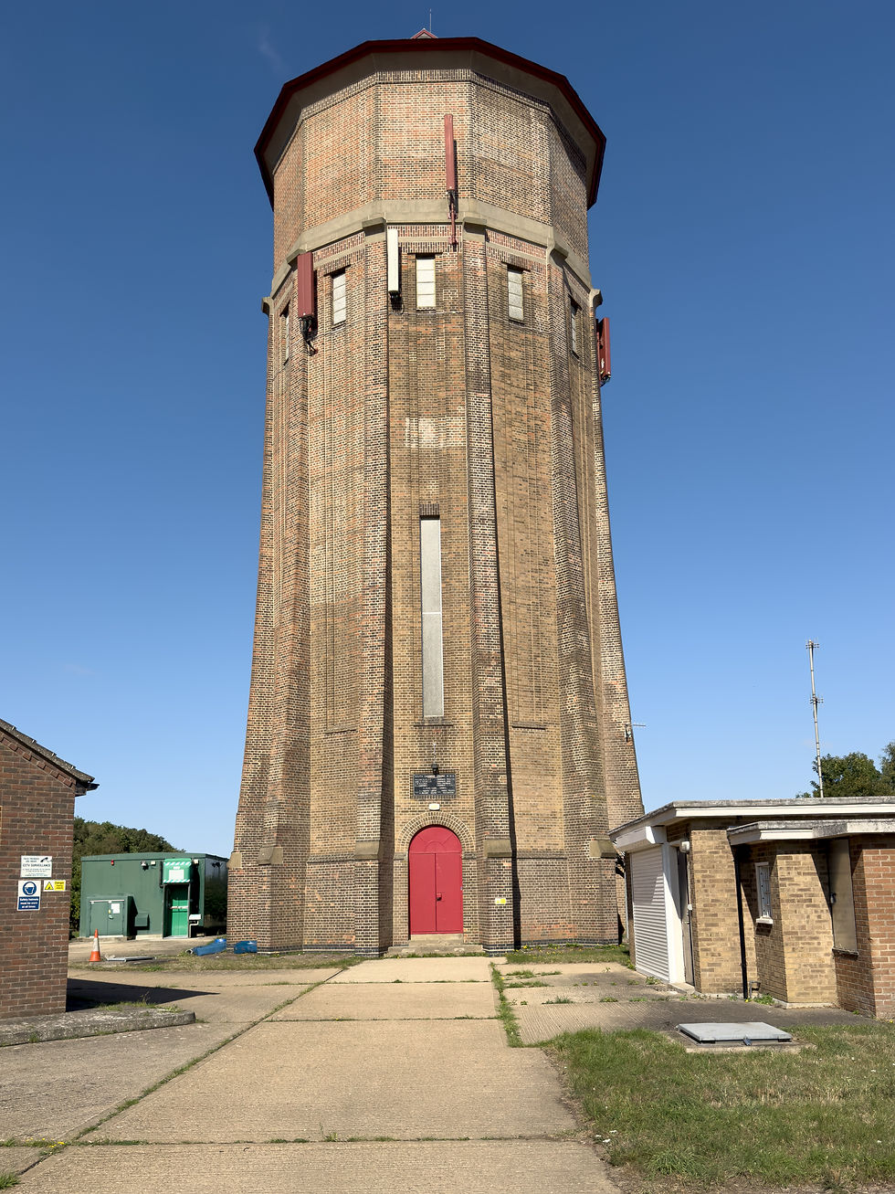
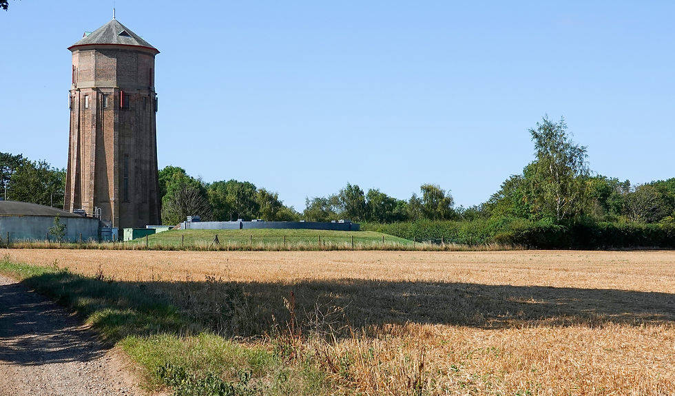
Perched at the top of the hill was Rivey Hill Water Tower, a 98 foot Grade II listed Art Deco tower built between 1935 and 1936. It has a dodecagonal brick exterior. For its age it looked mighty fine but that’s because the masonry had a bit of a makeover in 2018. Shame about the mobile phone gubbins attached to it however! The tower can be seen for miles around.


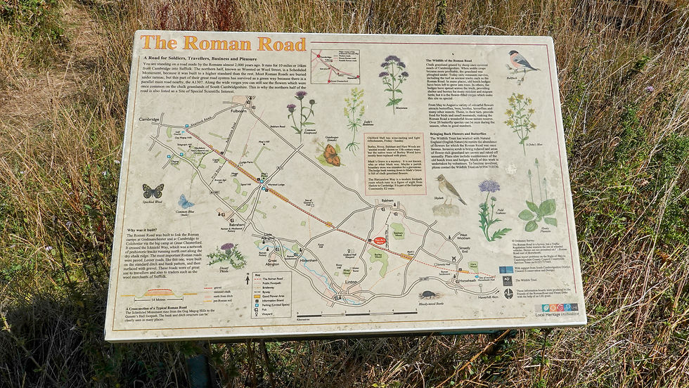
Beyond Rivey Hill, I continued along a well defined path across a number of recently harvested fields until I reached what was a Roman road that ran between Cambridge and Suffolk. The path turned right here onto the road and continued for about ½ mile before turning left onto a wider track heading towards Balsham.


Balsham is a village about half the size of Linton. On the village green there was a stone plinth milestone for the Icknield Way advising me that I was 43 miles from the Peddars Way and 63 miles from The Ridgeway. Balsham is where the opening ceremony of the Icknield Way Trail took place in 1992.


The next 4½ miles were nice enough but nothing special. Much of this part of the trail was along stone and gravel tracks often sandwiched between hedgerows giving reduced views.


At Willingham Green the path crossed B1052 before heading cross-country to Brinkley and Burrough Green.


At Burrough Green I emerged onto the B1061 and across the road was a most inviting pub – The Bull. It was a hot day, so naturally I had to stop for a quick pint and a short rest. I surreptitiously ate my Sainsbury’s sandwich at the same time.


Burrough Green seemed to mark the start of horseracing Newmarket. The Icknield Way Path continued down the side of the pub and almost immediately I was walking alongside the paddocks of my first stud farm. At the next road the path crossed – named Cross Green - I was presented with Icknield Way fingerposts pointing in all directions. It was one of those places where the cyclists & horse riders went their own way whilst I was allowed to carry straight on. This is what I mean when I say you have to read the signs carefully!


The final mile into Stetchworth was more or less all dedicated to horses, be it paddocks or gallops.


I arrived at Stechworth at about 14:15. The local villages had come together to celebrate the 80th anniversary of VJ Day at the community centre in the village – Ellesmere Centre. There were a lot of people there and it looked like they were all enjoying themselves on a gorgeous summer Sunday afternoon. I however had to get back to my car in Cambridge. I knew there were no buses on a Sunday and my original plan had been to call for a taxi to take me to Newmarket Station from where I could get a train to Cambridge.

My other option was to walk to Dullingham Station which is on the same line as the Newmarket train. The station was about 1¾ miles from Stetchworth. The next train was due at 15:20, so I had almost an hour to walk there. Even on a hot day, this was plenty of time. I reached the station just after 15:00 so had 20 minutes to sit on a bench enjoying the sunshine and admiring the station’s colourful garden.


With the extra walk to Dullingham Station I’d walked almost 20 miles today. Yet another enjoyable stage through some beautiful Cambridgeshire countryside. Two more to go to complete the Icknield Way Path.


Comments